Thursday, February 28, 2013

Throwback: The Great Heat Wave of 1936

It is the end of February and spring is soooo close!! And we all know that spring means, tornado season!! I know that's exactly what you were thinking! Well, I suppose the temperatures are a tad warmer than they are now. On that note, I thought I would heat things up for this Thursday's Throwback with the Great Heat Wave of 1936.
The St. Paul Daily provided two fans and 400 pounds of ice to these ladies in the press room, during a 108 degrees day in Minneapolis, MN.
For anyone who was in the MidWest this past summer can contest that it was quite a scorcher. Can you imagine an even hotter summer? The Great Heat Wave of 1936 had seventeen states break or tie their all-time maximum temperatures, some of which still stand today. In fact, it wasn't until the 2012's summer that some of those maximum temperatures were even broken. I'll just say that during the 1936 summer a day time high of 100+ degrees was a norm.

To keep cool at night many people went outside to sleep. Pictured below is Lincoln, Nebraska on a hot July night, where the night time low didn't drop below 91 degrees. 
 
Well I hope that this warms up your Thursday! To tell you the truth I am look forward to the warm temperatures as well, just not the Great Heat Wave hot!


Photo/ Info From:
blogs.woodtv.com
blogs.kxan.com
wunderground.com

Wednesday, February 27, 2013

Wacky Weather: Blizzards Pummel MidWest

The second winter storm in one week has once again paralyzed the country's midsection. This storm has blanketed a wet 8-17 inches of snow across the heartland. And remember that the areas hardest hit already had an existing foot of snow from the last storm to come through the area, which was less then a week ago. The combination of these two major snow storms has broke Wichita, Kansas, record for being the snowiest month in its history with 21". While MidWest residents are excited to see the precipitation, these two major snow storms won't help busting the extreme drought. However, it will help replenish some of aquifers. 

This most recent storm has claimed three lives, two from a car accident and one from a roof clasping because of the amount and weight of the snow. Below is a picture from Jeff Master's weather blog showing the amount of snow from the most recent snow storm.


Photo/ Info From:
weather.aol.com
wunderground.com

Tuesday, February 26, 2013

Forecasting 101: Predicting the Weather without a Forecast

Yes, it can be done! Before technology and the advancements in meteorology, people had to rely on observations, patterns and folklore to prevent being caught off-guard by the elements. Actually, during hurricane season back in the day before satellites and radar, if a hurricane would hit the Caribbean, they would alert the rest of the Gulf of Mexico coastline. There are a many things that go into making a forecast without any models.

The first thing that you should do is look outside. This may seem quite obvious but observing the current conditions is the first thing that one would do to begin any forecast. A good place to start is looking at the type of clouds above and which direction they are moving.

1. Clouds: Clouds are a great tell tale sign of what is going on in the upper atmosphere. I put together a little chart for what precipitation can be associated with some common cloud types. While there is always a chance for these clouds to form with no precipitation, generally you can expect these clouds to produce some precipitation. If want to brush up on some of the basic clouds read my earlier post which you can easily get to by this Link to Cloud Basics.
2. Wind Direction: All right so you have observed the clouds, the next important step is to check the wind direction. If the wind is calm or undetectable, try throwing some grass in the air. In a general rule of thumb, winds that are coming from the east means precipitation is very likely. While, winds blowing from the west favors fair weather. Below, is Wendy Ward checking the wind by throwing some grass in the air.
http://ww3.hdnux.com/photos/16/40/42/3803274/5/628x471.jpg
3. Smells: Believe it or not, the smells in the air can be an inkling of whether precipitation is in the near future or not. Does it smell like compost? When a storm system is approaching, plants will release their waste which can make it smell like compost. Swamps will also release gasses, in loom of an approaching storm, which can lead to unpleasant smells. Both plants and swamps do this because of the pressure drop from the approaching storm.

4. Observe Smoke/Steam: Building a campfire can also help detect precipitation. Usually smoke will rise steadily, however, if the smoke is swirling and then descends this means that a low pressure system is approaching. A low pressure is usually associated with wet weather.

There are many other ways to detect whether precipitation is coming, but these are some main factors that will help you predict the weather without a forecast. If you ever are in the woods or are in an area where there isn't an easily accessible weather forecast remember these weather techniques to keep you from getting caught in the storm.


Photo/Info From:
puma.com
wikihow.com
mysanantonio.com

Monday, February 25, 2013

Myth: When Dew Is On The Grass, Rain Will Never Come To Pass

Myth: If there is a morning dew on the grass then there will be no rain that day.
http://i674.photobucket.com/albums/vv107/znarf_18/morning-dew-on-grass-apple-ipad-wal.jpg
Answer: This myth is partly true.

The Science: Dew forms on the grass when the temperature cools to below the dewpoint. This usually occurs when there is a clear night sky. If these clear skies continue into the daytime hours then there will be no rain, however, we all know that weather can change fairly quickly and rain could move in. Don't you just love weather?


Photo From:
i674.photobucket.com

Wednesday, February 20, 2013

Wacky Weather in Northern California

Yesterday, California experienced everything from snow to rain and even a tornado. A system from the Gulf of Alaska brought some much needed precipitation to to the area. However, in the higher elevations where there was snow falling, caused many travel problems a stretch of Highway 58 had to be closed. This storm even spawned a couple of tornadoes near Red Bull. Luckily this tornado was weak and caused minimal damage, no one was killed. Below is a picture of the tornado.
An eyewitness spotted this tornado touching down in Tehama County near Red Bluff on February 19, 2013. (CBS)
Some people were enjoying the snowy conditions. This system is expected to move east, and provide the Midwest with some snowy conditions, as well stormy conditions in the south.
California snow
Photo/ Info From:
sanfrancisco.cbslocal.com
ctvnews.ca

Tuesday, February 19, 2013

Forecasting 101: Doppler Radar

Now before I tell you all about Radar, I would like you to know that Doppler Radar will be the name of my first dog, which will be a black Labrador Retriever. I am just not settled down enough to take on the responsibility of a dog yet, otherwise I would totally have one. Alright, back to weather!

Radar or otherwise known as Radio Detection and Ranging, is an instrument that uses radio waves to determine the range, altitude, direction, or speed of objects. Doppler Radar detects the intensity of precipitation, wind direction and speed, and droplet size. Doppler Radar uses the Doppler effect. The Doppler effect measures velocity of particles. Basically, an Austrian physicist, J. Christian Doppler, explained why a whistle of an approaching train had a higher pitch sound then when the train was moving away from a specific spot.

Doppler Radar sends out a radio signal and depending on how much of that signal is return is how intense the precipitation is.  For example, look at the picture above, the areas that are black are returning little to no signal and the areas in green and orange are returning a signal to the Doppler Radar. I hope this makes sense.

Meteorologist use Doppler Radar to measure tons of different elements. Today, computers can even detect whether there is a "Vortex Signature" within Doppler Radar data, which has greatly helped with warning people to take shelter for a tornado.

Photo From:
nicksmaps.blogspot.com

Monday, February 18, 2013

Myth: Leaves know when rain is coming

Myth: When leaves show their undersides, be very sure that rain betides. Well, if that was confusing basically it says that when a trees leaves turn upside down, rain is on it's way.
http://www.fotoplatforma.pl/foto_galeria/1250_DSCN1499.jpg

Result: Yes, for the most part this is true.

The Science: The leaves are reacting to the changes in humidity, which then soften the leave stalks making the leaves turn "upside down". Poplar trees are actually very good at predicting whether rain will be coming.

 Photo From:
fotoplatforma.pl


Thursday, February 14, 2013

Valentine's Day and Weather

Happy Valentine's Day everyone!! I bet you are wondering how on earth am I going to connect Valentines Day and weather... Well, what if I told you that the things that you would usually buy on Valentines day are influenced by the weather.

Yep I said it, those flowers, wine and chocolate you buy around this time can either be abundant or scarce depending on the weather. I'm sure you can already say to yourself that flowers are outside so of course they are influenced by the weather. In fact, a rose bush will suffer damage if the temperature falls below 55 degrees or rises above 86 degrees. Good thing we have green houses!

Now what about that wine. Good wines and bad wines are all based on the type of weather that the vineyard had that year.

And chocolate, as many of you know, comes from the cocoa bean. I am not sure how many of you have been to Hershey, Pa and gone through the Chocolate World tour but a cocoa bean comes from a cacao pod which grows on a cacao tree. If you ever get a chance to visit Hershey take the tour, it's actually pretty neat and smells delightful!!

So when you are out buying Valentine's Day goodies, remember that weather had a part to play in what you are buying.

Photo From/ Info From:
ouramazingplanet.com
winetherapy.co.uk

Wednesday, February 13, 2013

Wacky Weather: Antarctica Lake Research

Alright, so this isn't exactly wacky weather, but I think that it's pretty cool and thought you would think so too. United States researchers have drilled into a Lake Whillans, which is buried 2625 feet below the surface in Antarctica. The sub glacial lake contains some bacteria. I know this must seem moot, but think about the harsh environment that this bacteria has to live in, in order to survive. The scientist have collected 8 gallons of water from this lake, in which they plan on doing further studies on these organisms.
 

Photo and Info From:
ouramazingplanet.com

Tuesday, February 12, 2013

Forecasting 101: Thundersnow

Thunder is not a sound you would expect to hear in a snowstorm but it does occur. Lighting can also sometimes be seen in a snowstorm as well. This picture below is of a Weather Channel reporter experiencing thundersnow.


Thundersnow is exactly what it sounds like, thunder and lighting during a snow storm. It's rare to have thundersnow because you need a snowstorm with convection, like in a summer thunderstorm. But, in the winter time this is very hard to achieve, because it is nearly impossible to have atmospheric instability during the winter.  Intense snowfalls like conditions experienced during last weekend snowstorm can usually produce thundersnow, however, thundersnow is most common in storms that are late in the winter season.

I can go into more detail on this topic if you would like, it just gets very technical. Have any questions feel free to ask!!

Photo From:
dailyvsvidz.com

Monday, February 11, 2013

Myth: Woolly Caterpillars Can Predict the Harshness of Winter

Myth: The Woolly Caterpillar is claimed to predict the harshness of  the impending winter weather. These caterpillars have black and brown banding in their back. The folklore states that more black than brown indicates a harsh, cold winter while more brown than black points to a mild winter.

http://www.organicgardening.com/sites/default/files/wolly-bear-caterpillar-400.jpg

Results: There is not enough evidence to make this myth true. There haven't been enough studies to make a link between Woolly Caterpillars and harshness of winter.

The Science: Although there is not enough research done on this particular topic. One entomologist, Mike Peters, from the University of Massachusetts stated that the brown hairs on this caterpillar is due to its age.  

Photo From:
organicgardening.com

Info From:
almanac.com

Friday, February 8, 2013

Friday: East Coast Hurricanes Through the Years

I stumbled upon some Hurricane History provided by the National Hurricane Center. Because Sandy is so fresh in my mind and I am sure some of your minds as well I thought I would share some of the other big hurricanes that have hit the East coast since 1938. Now just to let you know the National Hurricane Center did not start naming hurricanes until 1953, so prior to then they were just given the name of the town they destroyed. Also the Saffir-Simpson scale was not used until the 1970's, so any prior storms were not assigned a category till way after they had hit.

The New England Hurricane (1938)
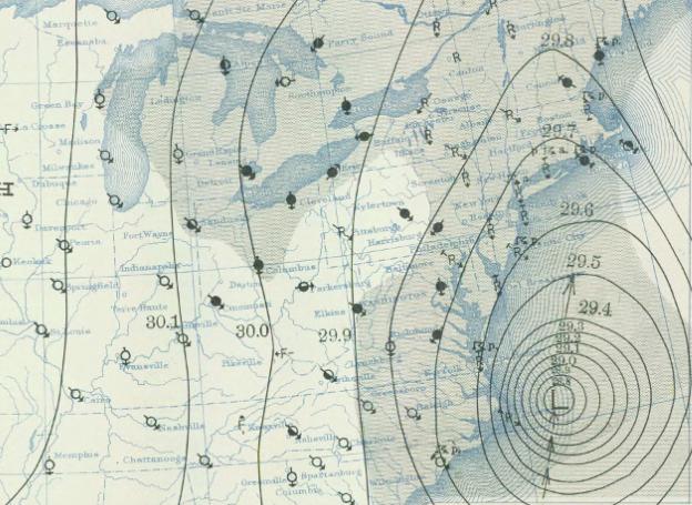
For example, in September of 1938 the New England Hurricane made landfall. Another name for this hurricane was the "Long Island Express". This was the first hurricane to hit the Northeast since 1869. The New England Hurricane was later deemed a category 3 hurricane with the sustained wind speed of 121mph recorded at Blue Hill Observatory in Massachusetts. The U.S Coast Guard recorded storm surges of 10 to 12 feet along Long Island and Connecticut. This Hurricane was the cause of nearly 600 deaths and 308 million dollars in damage. Below is a weather map from 1938 of the New England Hurricane.
File:1938 hurricane September 21, 1938 weather map.jpg
This is a picture of some Boston flooding after the New England Hurricane of 1938.


The Great Atlantic Hurricane (1944)
Another strong hurricane hit this region in September of 1944. This one was called the Great Atlantic Hurricane. The Great Atlantic Hurricane skirted along the eastern sea board, bringing 134 mph sustained winds at Cape Henry, VA. Hurricane force winds were experienced all along this storm track from North Carolina to Massachusetts, including a maximum gust of 109mph reported in Hartford, CT. Rainfall totals ranged from 6 to 11 inches. There was very good warning for this hurricane. Only 46 deaths were reported on land. However, one of the US destroyers, USS Warrington, sunk due to the storm, claiming 344 lives.


Hurricane Carol (1954)
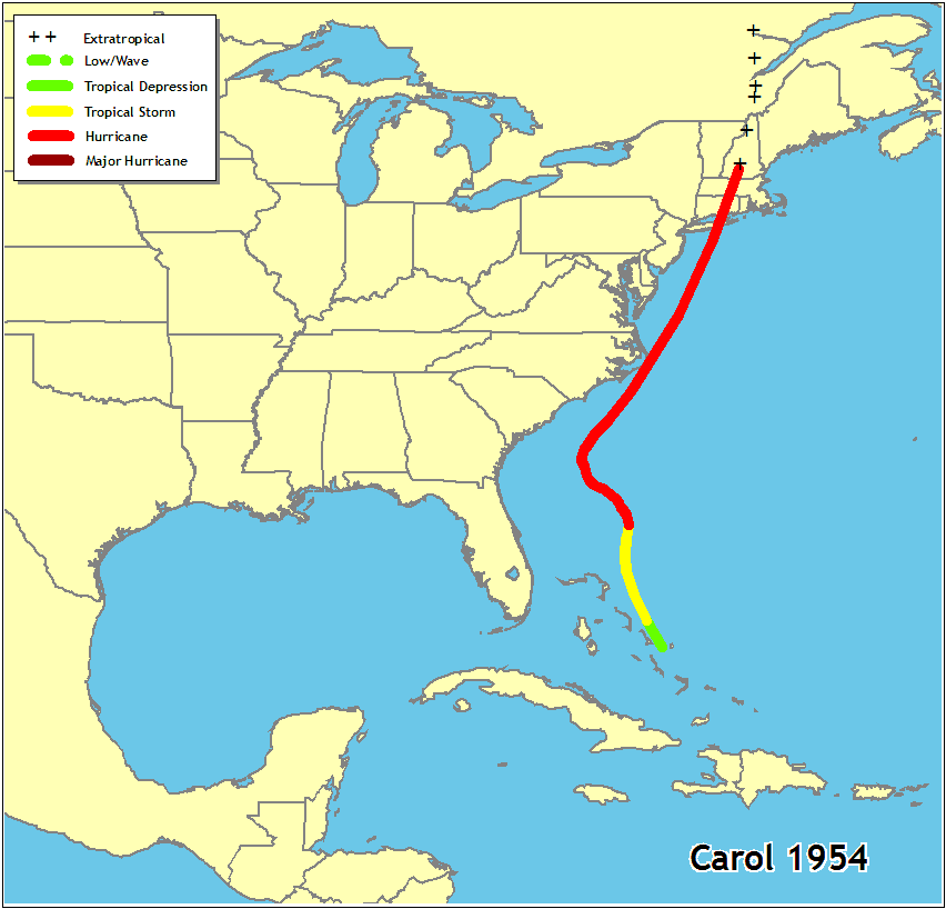
Late August of 1954, the second year of named storms by the way, Hurricane Carol made landfall over Long Island, as a later deemed category 3 hurricane.  Sustained winds of 80 to 100mph were recorded over much of eastern Connecticut and Massachusetts. Storm surges brought 8 to 10 feet of water into downtown Providence. Hurricane Carol was responsible for 60 deaths and 461 million dollars in damage. Below is a picture of Bristol, CT, and then below that is a track of Hurricane Carol.


Hurricane Edna (1954)
Talk about your "One-two Punch". Hurricane Edna came just a week after Hurricane Carol hit. Luckily, Hurricane Edna did not take the exact same path as Hurricane Carol and only skirted Cap Cod as a category 3 hurricane. Below is the track of Hurricane Edna.


Hurricane Donna (1960)
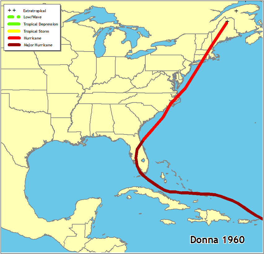
First detected on August 29th, Hurricane Donna quickly became a hurricane on September 1st. Hitting the Florida Keys and Southwest Florida hard as a category 4 hurricane on September 11th. Hurricane Donna then continued up the coast hitting North Carolina as a category 3 hurricane and then New England as a category 3 hurricane as well. Hurricane Donna is the only hurricane to produce hurricane force winds in Florida, North Carolina, and New England. Hurricane Donna also was responsible for storm surge ranging anywhere from 5 to 13 ft. Heavy rain fall was also associated with Hurricane Donna.

This picture below is from New England when Hurricane Donna hit.


Hurricane Agnes (1972)
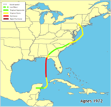
Mid June was the first named storm of the season and was one to remember. Hurricane Agnes hit the Florida panhandle and moved through the southeast emerging back out into the Atlantic. Hurricane Agnes then made landfall again near the New York, New Jersey. Although, this hurricane wasn't known for it's winds. Hurricane Agnes is known for it's major rainfall. Inland flooding was the major problem was what made this hurricane so memorable.


Some of the areas hardest hit included the Harrisburg area which recorded over 15" of rain, Baltimore, and Scranton was another city that still has flood lines on buildings from this hurricane. Below is a picture from the Balitmore area after Hurricane Agnes hit.


Hurricane Bob (1991) 
Hitting Rhode Island as a category 2 hurricane on August 19th, Hurricane Bob made quite the mark on the New England. Hurricane Bob was the second costliest hurricane at the time. Although, Hurricane Bob quickly weakened as it made landfall, stations did record 105mph winds.
File:Hurricane bob 1991.gif


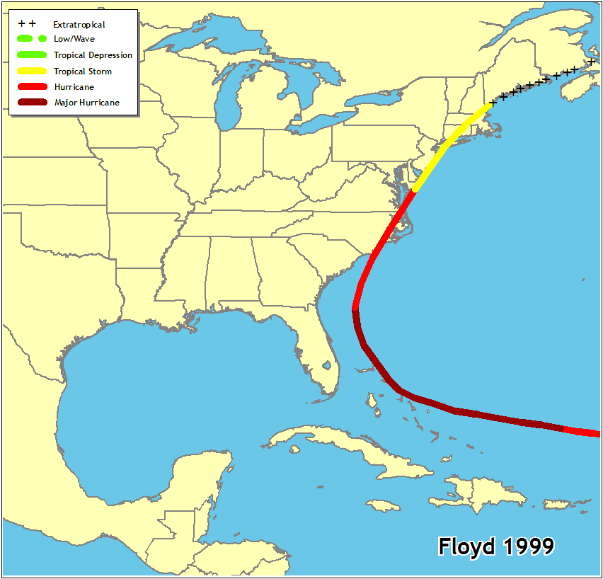
Hurricane Floyd (1999) 
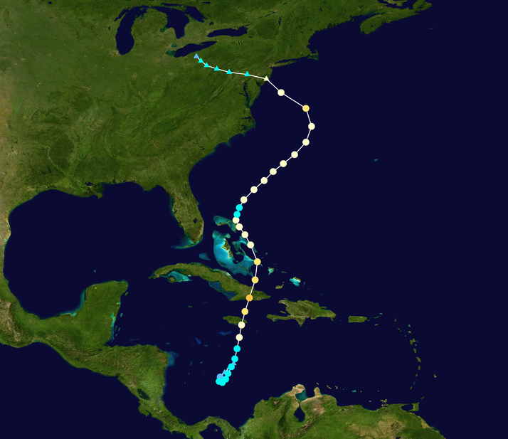
Alright, so I would like you all to know Hurricane Floyd is one of the largest reasons I became a Meteorologist. Hurricane Floyd first made landfall in North Carolina with winds of 120mph and storm surge of 9 to 10ft. However, Hurricane Floyd was remembered for it's rainfall. Below is the track of the storm.

So why was this hurricane such an influence on me becoming a meteorologist, well it was the first storm that me and my dad tracked. Following whether or not the eye was going to reform was really exciting. Science was something that I already enjoyed and ever since that I have been super in tuned with what the weather is and what could and is going to happen. In the Lehigh Valley, where I lived at the time, we received 12 inches of rain. The east was in a drought and this Hurricane helped put a dent in it. Look at this picture from New Jersey.


Hurricane Irene (2011)
In late August, Hurricane Irene headed north, first hitting North Carolina with sustained winds at 85mph. It then continued northward skirted along the Jersey Shore and completely made landfall over Brooklyn. However, Hurricane Irene continued to reek havoc on New England. Strong winds and heavy rainfall devastated Vermont and New Hampshire.  


Hurricane Sandy (2012)
Well, I know this hurricane is fresh in everyone minds. Hurricane Sandy, formed late in the season and when it made landfall was an extratropical system. This made it hard for meteorologist to post warnings, because there wasn't defined lines on this type of storm. The storm surge was 10 to 14ft. Hurricane Sandy was also one of the biggest hurricanes, being about 900 miles in diameter. 
File:Sandy 2012 track.png 

These are most of the major storms that have hit the Northeast in the past century. I highlighted from what I thought to be a reliable source, the National Hurricane Center, but if you are interested I did find a Wiki Page with more information on Hurricanes that hit the Northeast.

I did this big throwback to make people understand that big, powerful hurricanes have hit New England before and will probably hit the area again. That we keep having "record breaking" damage, but my last statement is there is a lot more people and a more things that are much more expensive in years past, so is it really record breaking?


Photo From:
wiki.com
hurricanehistory.org
boston.com
preservebristol.blogspot.com
swellinfo.com
lawerancevilleweather.com
rememberingagnes.blogspot.com
vtdigger.org
blog.nj.com
Info From:
nhc.noaa.gov

Thursday, February 7, 2013

Throwback: Blizzard of 1978

Because of the impending nor'easter, I thought that I would give you a throwback from February 6, 1978. The Blizzard of 1978 hit the Northeast hard. This low pressure system moved up the coast coupling with an Arctic cold front, which is kind of the situation we got going on now, but I don't think that the cold air will work it's way in for some of the Mid-Atlantic states. Anyway, the public did not heed the National Weather Services warnings because they had been wrong many times in the past. When this storm didn't start when the meteorologist said it would people thought that they were wrong again, and started to go about their daily business. This made for a nightmare when the storm began to rear its ugly head towards the middle of the afternoon. People became stranded in their cars and at their businesses. This picture below if from Milton, Massachusetts.
https://blogger.googleusercontent.com/img/b/R29vZ2xl/AVvXsEiezmn6Hq4zS4VYlWHk1hUFXgCBrH0v9stgJ41YCiTskfVWqQ70DNp4XXIIXSTMkrfLDu3nH9PX_TRbPXW6IIB4ZOidp2ltJOt8MUnQb7sQ0YqYEAv32MlR_qZIXqebQi8z6q7PL4wV2Z0/s1600/1978.gif
Snow Totals:
Boston--- 27.1"
Rhode Island--- 27.6"
Atlantic City--- 20.1"
Wind Gust in Boston were recorded at 83mph.


Photo From:
thehistorytavern.blogspot.com

Wednesday, February 6, 2013

Wacky Weather: Record Tornado Outbreak

Last weeks severe weather outbreak, January 29th through the 30th, will be ranked as the third largest tornado outbreak during January since records began in 1950. There were 42 confirmed tornadoes by the National Weather Service from this outbreak. This picture below is from an iWitness weather user fshelton25. She said she was driving on I-75 in Adirsville, Goregia on Wednesday Janurary 30th.

The strongest tornado that occurred during this outbreak was a high end EF-3 tornado in Peachtree City, Georgia. 


Photo/Story From:
wunderground.com

Tuesday, February 5, 2013

Forecasting 101: High and Low Pressure Systems

On this lovely first Tuesday in February, I thought that we could get into some more details about High and Low pressure systems. I am going to try to be as simple as possible explaining what these two notorious weather terms actually mean, if I loose you send me your question and I will be happy to help ease your confusion. Below is a National Weather Service product form today, which you can see High pressure systems in blue "H" and low pressure systems in red "L".


First, I am going to cover High pressure systems. High Pressure systems or as some meteorologist refer to them as Anticyclones, are regions of sinking air. Below I found a diagram of a high pressure system. As you can see there is sinking motion and the wind surrounding the high pressure are moving clockwise.  High pressures are associated with nice and dry weather, however, some weak high pressures can have showers associated with them.
http://www.windows2universe.org/earth/Atmosphere/images/high_pressure_sm.gif

Now on to the low pressure systems.  Low pressures have a few names for them, but to keep it simple for today they can also be know as cyclones. An area of low pressure have winds converging at the center causing an area of rising air. Like in the picture below. An area of low pressure winds flow in the opposite direction as a high pressure, counterclockwise. Because of the upward motion associated with a low pressure system, this causes clouds and usually some sort of precipitation. But don't always think that if you have a low pressure system that rain is coming.
http://www.windows2universe.org/earth/Atmosphere/images/low_pressure_sm.gif

Hope that helps differentiate what the heck the weatherman is saying on TV! I think next week I'll go into fronts to help bring it all together. Hope you are having a great day.


Photo From:
noaa.hpc.gov
windows2universe.gov

Monday, February 4, 2013

Myth: If a Groundhog Sees His Shadow...

Myth: If a groundhog sees his shadow on Groundhog's Day (February 2), the weather will remain cold for six more weeks. If he doesn't see his shadow then there will be an early spring. It's that time of year, it is Groundhog's Day (again) and in light of this I thought it would be nice to dig around the myth that is associated with this day.
 
Answer: There is a very slim truth to this myth, however, Mr. Punxsutawney Phil cannot forecast your weather for the next six weeks.

The Science: During the winter if you can see a clean crisp shadow then it is likely cold outside, due to a cold dry air mass that is likely overhead. On the other hand if it is cloudy outside, hence no shadow, then there is likely a warm moist air mass overhead. This is what the myth is based on, but we all know that it could be cloudy and snowy, which is why this myth is not really true.

Fun Facts about Groundhog Day: This is the first week in February, the halfway point between the winter solstice and the spring equinox. 

So why do we take a rodents advice on the weather? Well, in the olden days they would watch for hibernating animals, like the groundhog, to come out of hibernation as a sign that winter was coming to an end. 

So how did this all start? Back in the 1800's some people of Punxsutawney, Pennsylvania went out looking for groundhogs on February 2nd, Candlemas DayCandlemas Day is a Christian holiday that marks Mary's ritual purification. It was even believed by early Christians that if the sun came out on Candlemas Day then winter would last for six more weeks. Anyway, the people of Punxsutawney made looking for groundhogs a tradition on this day, and in 1887 it became an official event in the town.


Photo/Info From:
mnn.com
infoplease.com
facebook.com