Monday, December 31, 2012

Throwback 2012 #1 Warmest Year on Record

Warmest year on record for most of the United States. Record keeping dates back to 1850.
 
Photo From:
csmoniter.com

Friday, December 28, 2012

Throwback 2012 #2 US Drought

One of the biggest events that happen in 2012 was the Extreme Drought that caught two thirds of the country by surprise. One of this drought was the lack of snowfall from the winter.
File:Current-USDM.gif

Photo and Info From:
noaa.gov

Thursday, December 27, 2012

Throwback 2012 #3 Superstorm Sandy

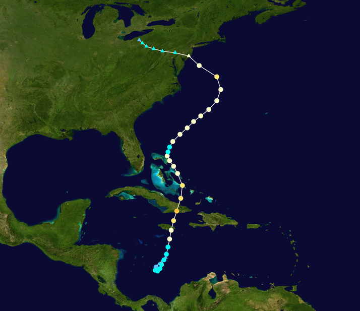
Obviously one of the big weather woes of 2012 was Superstorm Sandy, October 29th- 31st. This stormed had everything go right in terms of it becoming a monster superstorm. It started off as a low pressure system in the Caribbean. Sandy then moved on a Northerly path across Jamaica and Cuba. It then continued north. As Sandy continued it became influenced by a strong Low-pressure system and a deepening trough as it took its turn for New Jersey.  
 File:Sandy 2012 track.png
This storm has so many talking points I could go on for days about it, however, I'm sure the destruction is still very fresh in everyone's mind. Superstorm Sandy was unique unto itself. It brought hurricane force winds and storm surge to the Northeast and a blizzard like conditions to the mountains of West Virgina. This is one storm that we'll be talking about for years to come.

Photo and Info From:
wiki.com
noaa.gov

Wednesday, December 26, 2012

Throwback 2012 #4 Early March Tornadoes

Today's throwback is remembering the March 2nd-3rd, 2012 Tornado Outbreak. Much of the Ohio River Valley was affected by these storms. This outbreak caused 40 fatalities, 20 of which were in Kentucky. A deep low pressure over the Great Lakes allowed for the warm air from the Gulf of Mexico to come up to create prime atmospheric conditions for tornadoes. Below is a map of storm reports put together by the Storm Prediction Center. Keep in mind that several tornado reports can be for the same tornado.
File:SPC Severe weather reports 20120302.png

After the National Weather Service went to look at the storm damage they confirmed that there were 70 tornadoes during this outbreak. The maximum rated tornado was an EF 4. There were two that occurred during this outbreak. The first of the two occurred in Southern Indiana near New Pekin, Indiana. This EF 4 traveled almost 50 miles from New Pekin through Bradford, Kentucky, which in the very northern part of Kentucky. This tornado alone claimed 11 lives. This tornado is referred to locals as the Henryville tornado. I actually have a couple of friends that live down in that area and they said the devastation was terrible.

The second of the EF 4 tornadoes occurred in Crittenden, Kentucky. This tornado claimed 4 lives and destroyed 5 homes.

There was also several tornadoes that occurred in Alabama during this outbreak.

Photos/ Info From:
noaa.gov
spc.noaa.gov
wn.com


Tuesday, December 25, 2012

Throwback 2012 #5 Hail in Hawaii

Merry Christmas!! Your 2012 throwback is about Hail in Hawaii. Hawaii received a 4.25" hailstone on March 9th, 2012. The supercell thunderstorm also dropped 2-3" hailstones on Oahu, an island of Hawaii. This shattered the states old record of a 1" hailstone.

Hail formation is very rare in Hawaii. In fact, Hawaii only experiences about 20 to 30 thunderstorms a year. The very warm climate and warm atmosphere makes it very hard for supercell thunderstorms to form in Hawaii.

Photo/Info From:
Weather.com


Monday, December 24, 2012

Throwback 2012 #6 April's Abundance of Tornadoes

April Showers bring no Flowers? Well that's sure what happen this year. April 2012 was filled with supercell thunderstorms that spawned tornadoes all over the Mid West and South, however, the threat of tornadoes slowly diminished as the US moved into the summer months. Since there were a couple of large scale events, I thought it would be easier to group them into one single post.

First on the list of April Tornadoes is the tornado outbreak in norther Texas that occurred April 2nd and 3rd. The hardest hit areas were those that were around the Dallas, Fort Worth area. Specifically, a Suburb called Forney, Texas. An EF 3 tornado went through this town destroying many homes and even some of the school. However, fortuity no one was killed only a few were injured. Here is a photo of some of the damage in North Texas. Photo From: denverpost.com
title

The next tornado outbreak of 2012 occurred on April 13th-14th in the Great Plains. I remember the Storm Prediction Center had this outbreak predicted for over a week. There was all of the right ingredients for a large scale event to take place. This tornado outbreak had 114 confirmed tornadoes. The most severe tornado out of the outbreak was an EF 4, which occurred near Lyons, Kansas. Luckily, even with this large scale event only 6 tornado related fatalities were recorded. 

The other tornado outbreak occurred on April 28th- May 1st in the Ohio River Valley. This is a smaller scale outbreak compared to the April 13th-14th occurrence. The April 28th through May 1st outbreak only recorded 35 tornadoes. No fatalities were reported and the highest rated tornado was an EF 2 tornado.

Info from:
noaa.gov

Friday, December 21, 2012

Throwback 2012 #7 Hurricane Isaac

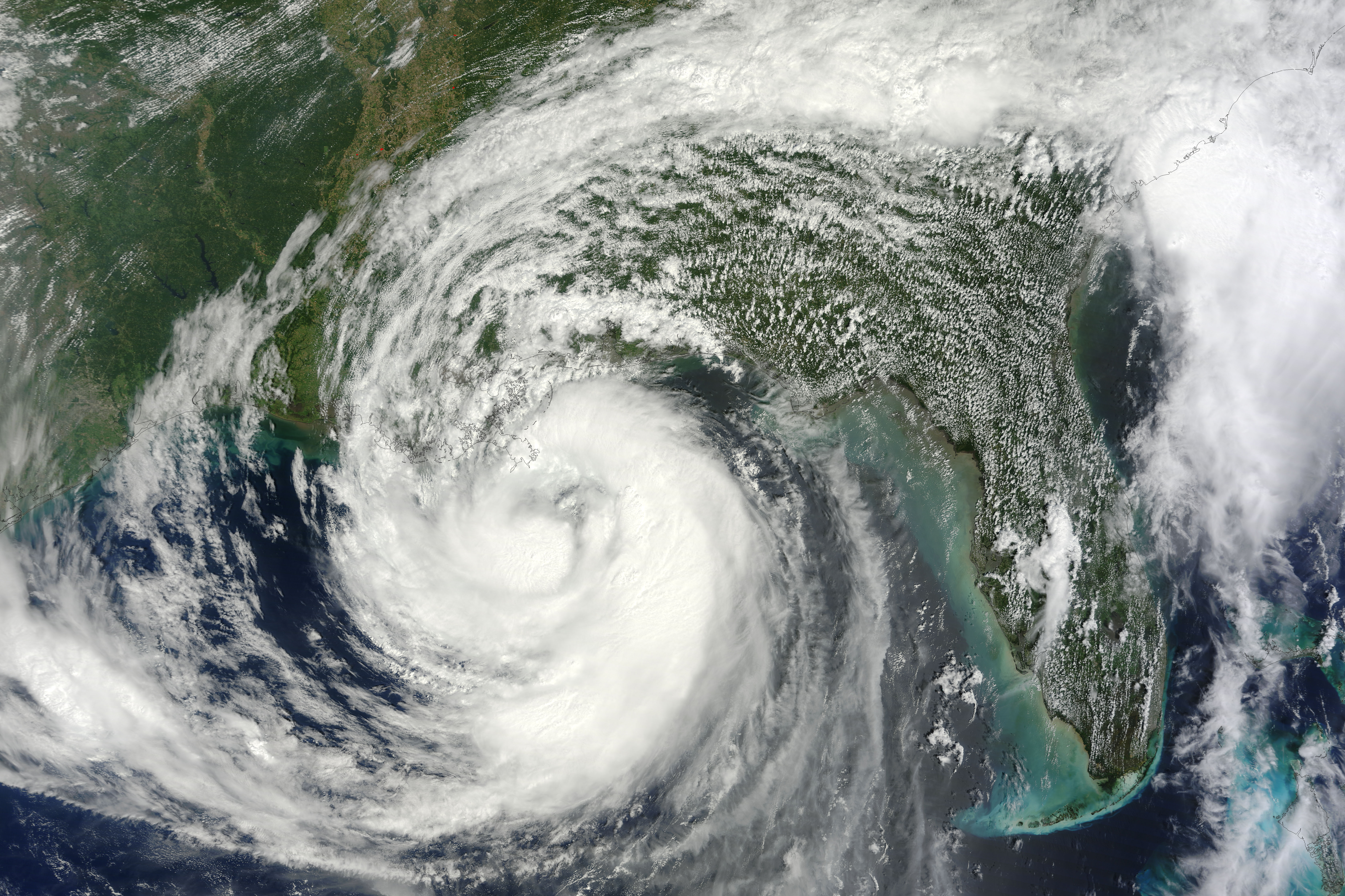
Today's 2012 throwback is Hurricane Isaac. In mid August, a tropical wave moved westward towards the Caribbean. It then strengthened to a Category 1 Hurricane as it moved through the Caribbean. Passing over Hispaniola and Cuba, Isaac claimed 29 lives. Hurricane Isaac did become a Category 2 Hurricane as it moved into the Gulf of Mexico.

Hurricane Issac then took sights on the Louisiana coastline. Ironically, Hurricane Isaac did make landfall in Louisiana exactly seven years after Katrina. Hurricane Isaac made landfall just southwest of the mouth of the Mississippi as a strong Category 1 Hurricane, Isaac did claim nine lives in the United States. Isaac then made it's way in to the drought stricken Mid West, bringing with it some much needed rain to parts of Missouri, Illinois, and Indiana.


Photo/ Info From:
nasa.gov

Thursday, December 20, 2012

Throwback 2012 #8 Bitter Cold in Europe

Your #8 Throwback of 2012 is going to take us across the pond to Europe. During February of 2012, Europe experienced bitter cold temperatures. Ukraine saw low temperatures as low as -33 degrees Fahrenheit.  The picture below was taken in Switzerland after an ice storm had hit during the February deep freeze.
 http://www.timeforkids.com/files/120208_frozeneurope_tout.jpeg
Even Rome, Italy received a dusting of snow. This was the first significant snowfall in the Mediterranean since 1986. This bitter cold left over 300 dead across Europe.

Photo/ Info From:
timeforkids.com

Wednesday, December 19, 2012

Throwback 2012 #9 Alaska Town Buried

Throwback of 2012 is going to take us up to Valdez, Alaska. Where a town was buried with about 7ft of snow in about a month time.
http://media.trb.com/media/photo/2012-01/201434040-06162533.jpg
Valdez is one of the snowiest cities in America, which receives about 27 feet of snow over about a 9 month period. However, 7ft in a month was too much for this Alaskan town to handle. There was reported drifts of 12-14ft of snow.
 
Info/Photos From:
accuweather.com
ktuu.com

Tuesday, December 18, 2012

Throwback 2012 #10 CO Wildfires

At #10 The Worst Wildfires in Colorado History.

The start of a wildfire can range from a cigarette butt to a strike of lighting, but once these bad boys start a blazin' they can be quite destructive, very dangerous and quite complex to get under control.

A combination of a very long dry period of weather, high temperatures, and low humidity made the 2012 fire season worst than normal all over the Western United States. In particular, the Waldo Canyon fire was the most devastating of them all.

A dry thunderstorm, just north and west of Colorado Springs, supported high winds and no rainfall creating a wildfire nightmare for firefighters. After this dry thunderstorm passed through on June 26th the Waldo Canyon fire spread at a rapid rate. A total of 346 homes were destroyed and over 18,000 acres were destroyed.

I wanted to clear up what exactly a dry thunderstorm is before preceding. A dry thunderstorm is a regular thunderstorm with lighting, thunder, and wind, however, the precipitation from a dry thunderstorm evaporates before reaching the ground.

Wildfires are very hard to control and usually at the bend of mother natures will.

Photo From:
theatlantic.com


Monday, December 17, 2012

White Christmas??

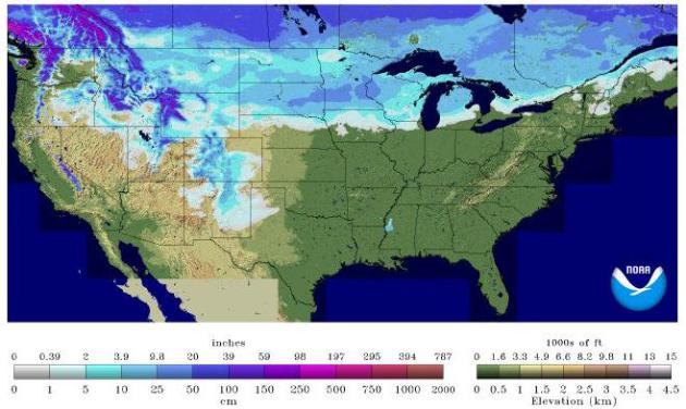
I'm dreaming of a white Christmas! However, all of you will not see my dream come true in real life. Right now we have several states who already have snow on the ground. Check out the current snow depth from the National Weather Service.
http://apps.startribune.com/blogs/user_images/snowdepthUSA_3.jpg
 With some new data in this is what I'm thinking for the United States snow cover through December 26th. These chances represent at least 1 inch of snow.

Hope you have a wonderful Holiday!! The next two weeks will be filled with throwbacks from 2012.

Wednesday, December 12, 2012

Wacky Weather: Snow in Texas

Dallas, Texas had it's first snow of the season, picking up 0.1" of snow on Monday, December 10th. Just north of Dallas, Wichita Falls which is pictured below had a heavier band of snow pass through and received about an inch and a half of snow. However, most of this snow did melt as temperature reached the lower to mid 40's across northern Texas.

The most interesting part about this story is that Dallas had it's first snowfall of the season before Chicago. That's right Chicago has not seen snow for 281 days. Chicago usually gets it first snowfall around November 16th. Its latest first snowfall occurred on December 16th, 1965. So it is possible we could see some more record breaking weather before 2012 closes out.


Photo/Info From:
myfoxdfw.com
wunderground.com

Monday, December 10, 2012

Myth: When a cow lies down, bad weather is coming.

Myth: It is believed that a when a cow lays down this means that a storm is coming soon. Many believe that the cow lays down for its joints are in pain because of the pressure change due to an impending storm.

Result: This myth, although sounds plausible, is not true.

The Reason: Cows can lay down for many reasons, it could be giving birth, sleeping, or dead. And most of the time bad weather does not come after it has laid down. With this information I would say this myth is busted!!

Happy Monday! And never trust a cow for weather advice!

Photo From:
the-picnic-site.com

Friday, December 7, 2012

New Hurricane Regulations

The National Hurricane Center is modifying its qualifications to issue a Hurricane Warnings north of North Carolina. The National Hurricane Center, NHC, had a boat load of criticism because of how they handled Hurricane Sandy's warnings. In all honesty they went by the book on this storm and didn't put out Hurricane warnings out in New Jersey, New York and Delaware. I say this because all of the models were forecasting that Sandy would transition into a post-tropical system meaning that it was no longer a hurricane before it made landfall. And the models were right, Sandy did become post-tropical before it made landfall, however, just because it became a post-tropical system didn't mean that the storm system would not have hurricane force winds and hurricane type storm surge.

I am not saying that if the Hurricane Warnings were issued that there would have been less damage. But I think that more lives would have been saved, and that the local authorities would have taken this storm more seriously and enforced evacuations within their city limits. However, that is all in the past and you can only learn and hopefully improve for next time, which is exactly what the National Hurricane Center is doing. Starting in 2013, the National Hurricane Center will have the wiggle room to issue multiple advisories on post-tropical cyclones. Ultimately this means they mended the qualifications for an Hurricane Warning to be issued.

Photo and Info From:
ouramazingplanet.com
io9.com

Wednesday, December 5, 2012

Wacky Weather: Tornado in Italy

Sometimes hard to believe that tornadoes occur in places other than the United States. These tornadoes aren't as frequent but they do happen. The southern part of Italy experienced a strong tornado last week. In a town called Taranto, which is highlighted in red on the map of Italy below. 
File:Map Province of Taranto.svg

The tornado stuck on November 28th. It hit a steel plant which injured some of the workers and one man is still missing. According to the European Severe Weather Database, this is the 9th tornado reported since October. This is quite high for Italy as in 2011 there were only 11 tornadoes reported. Below is a photo of the November 28th tornado in Italy.

Sorry for the lack of post for the beginning of the week, I was out of town. Happy Wednesday!!

Photo/Info From:
Wiki.com
avantyra.ru
Washingtonpost.com