Thursday, March 28, 2013

Throwback: Lituya Bay Tsunami/ Get Tsunami Ready

Now I know that you all are thinking, that you will probably never see a tsunami in your life time, so why should you know this information. Well, the answer is... when you are playing trivia this random information will totally come in handy! I love trivia! But seriously, wouldn't you rather be prepared than not.

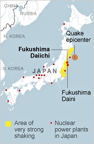
NOAA, the National Oceanic and Atmospheric Association, monitors buoys in the ocean that measure seismic activity. Underwater earthquakes are one of the big causes of tsunamis, and when detected by the buoys, warnings can be administered to the public faster. The faster the warnings are sounded, the faster people can get to safety. The safest place from a tsunami is inland, higher ground, or in a high building.

Remember tsunamis can also happen if a landslide causes a large amount of earth into a body of water. This actually happen in Lituya Bay, Alaska. In 1958, a earthquake caused a landslide of 30 million cubic meters to fall into the bay, this caused a huge tsunami that went 1720 feet up the opposing slope of the bay. While this kind of tsunami is rare, it is actually more dangerous and destructive then earthquake cause tsunamis. Below is a picture of Lituya Bay, where you can see all of the brown marks is where the tsunami hit.


This is just a reminder that tsunamis can happen anywhere so just be on alert! Happy Thursday everyone!

Photo From:
glogster.com

Wednesday, March 27, 2013

Wacky Weather: Earthquake in Mexico

Alright so earthquakes aren't exactly meteorology but they are still an earth science, and to be quite honest it was either talk about an earthquake or complain how it's not anywhere near warm! I thought that I wouldn't be a Debbie Downer and would focus on an Earthquake. In Santiago Pinotepa Nacional, Mexico a 5.5 magnitude earthquake shook most of southern Mexico.

http://www.lonelyplanet.com/maps/north-america/mexico/map_of_mexico.jpg
The epicenter was in Santiago Pinotepa Nacional which is about 200 miles from Mexico City, near Acapulco on the map above. There hasn't been any reports of injuries, but people said that buildings in Mexico City were shaking. 

Photo From:
lonelyplanet.com

Tuesday, March 26, 2013

Forecasting 101: Air Masses

An Air Mass is a large body of air in which the properties are the same in a horizontal direction. Air masses are determined by their temperature and moisture content. There are three different temperature categories for air masses: Arctic (A), Polar (P), and Tropical (T). The three different temperature categories are then paired with either a Continental (c) or a Maritime (m) to represent what moisture that particular air mass holds. Continental is a dry air mass while Maritime is a moist humid air mass. The type of air mass can usually be determined by where the air mass is coming from. For example look at the figure below from one of my text books. Note that most of the time Arctic air will not be associated with Maritime air. This is because Arctic air is so cold it can't not enough moisture to be considered Maritime.

 Air masses are important to pay attention to when forecasting because they usually hint to what what the weather is going to be moving in. I wanted to go over air masses because next week I am going to talk about the boundaries of air masses or what are commonly called Fronts! Yayyy! Get excited!!


Photo From:
geospatial.gsu.edu

Monday, March 25, 2013

Myth: Tsunamis are One Big Giant Wave

Myth: Tsunamis are one big giant wave.

In honor of this week being National Tsunami preparedness week!! I thought I would do a myth buster for your lovely Monday morning!
http://baghdadbythebaysf.com/wp-content/uploads/2011/12/karachitsunmai.jpg

Answer: No way! The picture above is not real!

The Science:  A tsunami is a series of low, fast and long ocean waves that can be caused by and earthquake or a sudden displacement of water. And most of the time the wave moves in all directions. Basically, just think of a tsunami as a wave that keeps on coming, not a huge tall wave. It's like a flood from the ocean or bay. I know that's not very scientific, but it is the only way I can think to explain it. The picture below is an actual picture from Japan.


Info/Picture:
baghdadbythebaysf.com
telegraph.co.uk

Thursday, March 21, 2013

Throwback: Hurricane Irene

In late August of 2011, Hurricane Irene formed in the middle of the Atlantic Ocean. It first made landfall in the Bahamas, then took a turn to the north.  Hurricane Irene weakened to a Category 1 hurricane before striking the North Carolina coastline with sustained winds at 85mph. It then continued northward skirted along the Jersey Shore and completely made landfall over Brooklyn, NY. Below is a track of Hurricane Irene.

As Hurricane Irene continued northward into New England, it continued to reek havoc. Strong winds and heavy rainfall devastated Vermont and New Hampshire.  Total storm damage cost 15.6 billion dollars, which makes Irene the 7th costliest hurricane. The cover bridge below is just one of many that were destroyed because of Hurricane Irene, and most of these bridges were over 100 years old.


To check out more Hurricanes that have hit the East Coast check out my earlier blog post, East Cost Hurricanes Through the years.


Photo and Info From
noaa.gov
vtdigger.com

Wednesday, March 20, 2013

Wacky Weather: Late Season Snow Storms

Happy First Day of Spring!!! Although, most of us still feeling a winter chill. In meteorology talk, there is a blocking High Pressures system in Canada keeping the Jet Stream south giving the MidWest and East a very active and cool weather pattern. Unfortunately, for you looking for spring, this pattern looks to persist into the first week of April. I found a graphic from AccuWeather that perfectly describes what I am trying to say.

The most recent winter storm hit the northeast yesterday, dropping anywhere from 1 to 6 inches of snow from Philadelphia to New York.  And models are hinting to yet another late snow storm for the MidWest and East next week! Get ready, winter is not over yet! (even though I wish it was)


Photo From:
accuweather.com

Tuesday, March 19, 2013

Forecasting 101: Flooding Types

As Meteorologist, one must look at several factors in order to decipher whether some sort of flooding is possible. Remember, it doesn't always have to rain in your backyard for it to flood. 
http://kwtv.images.worldnow.com/images/7515388_BG1.jpg
There are various reasons that flood can occur under, for example; multiple days of rain, snow melt, poor drainage. However, to break it down there are three main types of flooding.

1. Is your A-typical Basic Flood, which is commonly called "river flooding". This type of flood is caused by an overflowing river or some similar body of water that last for an extended amount of time, usually greater than 12 hours. This type of flooding is generally due to an excessive amount of rain over a couple of days. However, snow melt can be another cause.

2. Flash Flooding, is when an area receives an excessive amount of rain in a short time. This type of flooding can cause poor drainage areas to flood very suddenly. A big cause to flash flooding can also be leaves or clog drains, because there is no where for the water to drain in piles up and floods. Flash Flooding is probably the most severe kind of flooding because it can happen so quickly and catch people off guard.

3. Coastal Flooding, occurs when strong onshore winds push water from an ocean, bay or inlet onto land. This type of flooding can form from storm surges associated with tropical storms and hurricanes, or can be associated with non-tropical storms such as "nor'easters".


Info/ Picture From:
Noaa.gov
weather.com
news9.com

Monday, March 18, 2013

Flood Safety Awareness Week

Thought I would inform you all that it is Flood Safety Awareness Week. It floods somewhere in the United States or its territories nearly every day of the year. Flood waters have caused about 8 billion dollars in damage in the past 30 years as well as claiming about 100 lives per year. That is more then hurricanes and tornadoes! Being prepared in advance and knowing a few flood safety tips will help you and your family survive a flood if it happens in your area.

Know your risk! Ask yourself, Do you live in a flood prone area? If you are not sure contact your local National Weather Service office and find out. Knowing this information is very important!

Do you live by a river? If so it might be a good idea to visit and maybe even book mark the Advanced Hydrologic Prediction Service (AHPS). This service forecast how high the flood waters will be across the United States.

The most important thing I can tell you is if a road way is covered by water, DO NOT TRY TO GO THROUGH! Driving is actually the biggest killer when it comes to Flood Waters.
flooded road with Turn Around Don't Drown sign


These are just a few tips to help you prepare for a flood. For more information, please visit The Flood Safety Awareness website at
www.floodsafety.noaa.gov

Knowing your flood risk, how to prepare for and actions to take before, during, and after a flood can save you time, money, and even your life. 


Photo and Info From:
Noaa.gov

Thursday, March 14, 2013

Throwback: Tohoku Earthquake and Tsunami

Monday marked the two year anniversary of the Tohoku earthquake and tsunami. March 11th, 2011 Japan experienced a 9 magnitude earthquake. This massive earthquake then sparked a tsunami which hit the Japanese coast just minutes after the earthquake. Survivors said that they wave reached about 23 feet in height. Unfortunately, 2994 lives were claimed during this event and over 6000 people were injured. Japan is still suffering from the effects of this event. In fact, according the Japanese Government over 300,000 are still homeless due to the event.

One of the biggest worries from this disaster was the fact that there were several Nuclear Plants in danger from the tsunami waves. Below is a map of Japan and where all of the Nuclear Plants are located. The experts claim that the radiation that was leaked at Fukushima was non life threatening.

http://www.nonukesyall.org/images/Japan_nuclear_map.jpg
Photo/Info From:
freeandhandy.com
planetearthandhumanity.blogspot.com
ouramazingplanet.com
forbes.com
hiroshimasyndrome.com

Wednesday, March 13, 2013

Wacky Weather: Comet PanSTARRS

Comet PanSTARRS has been making its way past earth for the past couple of weeks, and just recently has become visible in the Northern Hemisphere. And don't worry it is a good 100 million miles away, but in space that means it close enough to see here on earth. I found a video time lapse of the comet sighting in Arizona.
 
There is a another chance to see Comet PanSTARRS tonight, low in the west after sunset near the moon. I found a photo to help you find the comet, remember make sure that trees and tall buildings are not in your way.
Let the waxing crescent moon be your guide to the Comet PANSTARRS on Wednesday, March 13.

Also if you don't get a chance to see this comet, there is a chance to see another comet later this year!! Get excited!! 
 
Photo/Video From:
earthsky.org
youtube.com

Tuesday, March 12, 2013

Forecasting 101: All About Hail

I thought that will severe weather season just around the corner for most of us that I would tell you about hail. Hail is a really neat weather phenomenon. Hail is formed when small water droplets are caught in the updraft of a thunderstorm. Before I go any further, I want to teach you about what an updraft is. Refer to the figure below of a basic thunderstorm anvil. Both the updraft and the downdraft are essential parts of a thunderstorm, without them the thunderstorm would not exist or would be weakening significantly.

Now we have water droplets caught by the warm updraft, these particles are lifted high within the cloud until they are frozen. The now ice particles descends, however, if the melting ice particle descends near the updraft they can be once again lifted high within the cloud and will refreeze. This process will continue to occur until the updraft cannot support the weight of the ice particle, also known as hail, at this time the hail will fall to the ground.

I want you to think about how strong the winds have to be within a cloud to support the growth of some of the hail that has been recorded. For example, the largest hailstone recorded to date is 8 inches in diameter and weighs almost one pound! This means that the updraft speed had to be somewhere around 200 miles per hour. That is one severe storm!!


One side note, if you ever are taken pictures of hail (which I know you all do! ha) make sure you put something in the picture like a quarter. It's actually super hard to tell how large a hail stone is without a visual comparison. 

Sorry this one is late the rain storm this morning made my wifi super slow. 

Photo From:
wximpact40-88.pbworks.com
Meteorologynews.com

Monday, March 11, 2013

Myth: No weather is ill, if the wind is still

Myth: There will be no "bad" weather, if the wind is still.
http://cmsimg.mansfieldnewsjournal.com/apps/pbcsi.dll/bilde?Site=B7&Date=20121228&Category=NEWS01&ArtNo=121228002&Ref=AR&MaxW=640&Border=0&Under-Weather-More-snow-way
Answer: Mostly True.

The Science: Still or calm winds are usually found towards the middle of a high pressure system or air mass. While precipitation is usually found near the boundaries of air masses.  This is why if the winds are calm or still that there shouldn't be any precipitation. However, there is always that chance that it could be wrong.

Side note, there is no "bad" weather or "good" weather. Weather is just weather, people just associated rain with "bad" weather and sunshine with "good" weather. 


Photo From:
mansfieldnewsjournal.com

Friday, March 8, 2013

Friday: National Severe Weather Preparedness Recap

If you missed this week's Severe Weather Preparedness Week, don't worry, I thought that I would give you all a recap of what you learned this week. Because it is super important that you know all of these things when severe weather does hit.
http://www.nws.noaa.gov/com/weatherreadynation/files/NSWPW_poster_2013.jpg
Thunderstorms and Tornadoes can move in any direction! If you see these terms flashing across the screen you know what they mean:

Severe Thunderstorm Watch: A "Watch" means that you should be alert for severe weather later in the day or night.
Severe Thunderstorm Warning: At this time you should take shelter while the storm passes.

You need one of these three things for a Thunderstorm to be severe:
1. Producing one inch or larger in diameter hail
2. Producing winds equal or exceeding 58 miles per hour
3. Producing a tornado

Each year, many people are killed or seriously injured by tornadoes and other types of severe weather, despite advance warning. In 2012, there were more than 450 weather- related fatalities and nearly 2,600 injuries. Every state in the United States has experienced tornadoes and severe weather- 46 states reported tornadoes in 2012- so everyone is exposed to some degree of risk. Often the real "first responders" to an emergency don’t have flashing lights and sirens. They are moms and dads, store managers, and teachers. What they do before, during, and after an emergency can save lives.

Basically just take precaution when severe weather is in your forecast!  Stay Safe Everyone and Happy Severe Weather Preparedness Week!

Photo and Info From:
noaa.gov

Wednesday, March 6, 2013

Preparing For Wacky Weather

National Severe Preparedness Week

This week is the National Severe Preparedness Week! In order to get you all ready for the storm season, I thought I would theme this week's blog posts as "Severe Weather". We will be continuing your Severe Preparedness Week with how to be prepared when the severe weather hits!

If you find yourself in the path of a severe storm make sure you are taking precautionary measures to keep yourself and people around you safe.

If you are outdoors and there is a chance for severe weather, make sure you are keeping an eye to the sky. Look for darkening skies, flashes of lightning or increasing winds. If you are indoors try to stay away from windows and do not go out onto your porch. Remember just because you are indoors does not mean you are safe from lightning. 

My biggest take home point would be if you see some get struck by lightning... go help them! You will not get electrocuted by touching a lightning victim, but there sure do need you to call 9-1-1! Basically, this week is to remind you to heed warnings from your meteorologist! If they are telling you to take shelter, it's probably a good idea. I know all of this stuff seems basic but it's good to have a refresher every once and a while.


Photo From:
prepare.ua.edu

Tuesday, March 5, 2013

Forecasting 101: Thunderstorm Basics

National Severe Preparedness Week

This week is the National Severe Preparedness Week! In order to get you all ready for the storm season, I thought I would theme this week's blog posts as "Severe Weather". We will be continuing your Severe Preparedness Week with a lesson about severe thunderstorms!
 
So what is a thunderstorm? By definition a thunderstorm is a rain shower that has both thunder and lighting. A thunderstorm becomes severe when it produces one inch or larger in diameter hail, and/or winds equal or exceeding 58 miles per hour and/or is producing a tornado.

I know sometimes it can be confusing deciphering what the difference between a watch and a warning are, so I put the definitions below with what it all actually means. 

Severe Thunderstorm Watch: A watch is issued by the Storm Prediction Center which is part of the National Weather Service. They issue a watch when conditions are favorable for the development of severe thunderstorms in and close to the watch area. They are normally issued well in advance of the actual occurrence of severe weather. A "Watch" means that you should be alert for severe weather later in the day or night.

Severe Thunderstorm Warning: A warning is issued by your local National Weather Service Office. A Severe Thunderstorm Warning is issued when the Doppler Radar or storm spotter has reported hail larger than one inch, winds equal or exceeding 58 miles per hour, or a tornado has been spotted. A "Warning" means that a severe storm is occurring and heading in your direction. At this time you should take shelter while the storm passes.


Photo From:
srh.noaa.gov

Monday, March 4, 2013

Myth: Thunderstorms and Tornadoes Always Move From East to West

National Severe Preparedness Week
http://www.nws.noaa.gov/com/weatherreadynation/files/NSWPW_poster_2013.jpg
This week is the National Severe Preparedness Week! In order to get you all ready for the storm season, I thought I would theme this week's blog posts as "Severe Weather". We will be starting off your Severe Preparedness Week with a myth buster about thunderstorms and tornadoes!

Myth: Thunderstorms and Tornadoes Always Move From East to West
http://www.physicalgeography.net/fundamentals/images/thunderstorm.jpg
Answer: Sometimes True. Man, if this was always true my job would be so easy!

The Science: Atmospheric conditions dictate where, and how a storm will form and move. Tornadoes and Thunderstorms can move in ANY direction!


Photo From:
physicalgeography.net