Thursday, January 31, 2013

Throwback: Hurricane Andrew

This first named tropical cyclone in 1992, left big marks in the record books! In August 1992, a tropical wave developed in the middle of the Atlantic Ocean. In its beginning stages Hurricane Andrew looked like it wouldn't become a hurricane at all. However, a significant decrease in upper level wind shear gave this storm all it needed to become a very powerful category 5 hurricane. 
http://www.communitynewspapers.com/wp-content/uploads/2012/08/andrewpeak1-300x167.jpg
Hurricane Andrew devastated the southern coast of Florida. Fortunately, Hurricane Andrew was a relatively small hurricane. Take a look at some of the pictures below of Florida after Hurricane Andrew. This picture below is from Palm Beach, FL.

After Hurricane Andrew destroyed most of Southern Florida in went into the Gulf of Mexico, where it met some unfavorable conditions and weekend to a category 3 hurricane. However, Hurricane Andrew turned Northwest and narrowed it's eyes to the Louisiana coastline. Making landfall at Morgan City, LA, Hurricane Andrew quickly decreased in intensity. Overall, Hurricane Andrew was the cause of 65 deaths and 26 billion dollars in damages. It is the 5th costliest hurricane in US history, sitting behind Hurricane Wilma(2005), Katrina(2005), Ike(2008) and Sandy(2012).


Photo From:
communitynewspapers.com
palmbeachpost.com

Wednesday, January 30, 2013

Wacky Weather: Spring like temperatures in January

We don't have to go far for this week Wacky Weather. Most of the country is on a temperature roller coaster ride. While most of us are welcoming this warm air in the middle of winter, spring like temperatures brings spring like severe weather with it. That's right, thunder, lighting, hail, strong wind, and even some tornadoes are being recorded over the country. Below is a picture of storm reports from the past 24hrs from the Storm Prediction Center. 

I also dug up the temperature map from a week ago when most of the country was in a deep freeze and compared it with today's temperature map. Below the two maps on tops are from Jan. 22, 2013 and the two maps on the bottom are from Jan 29th, 2013.
Click Image For MAX/MIN Station Plots
Hope you enjoy the warm weather while you can! The cold weather and snow will be returning very very soon!

Photo From:
http://www.hpc.ncep.noaa.gov

Tuesday, January 29, 2013

Forecasting 101: Wind

Wind has so many different elements in forecasting it would take me weeks to explain it all to you. However, today I want to cover three basic questions about wind: What is wind? What causes the wind to blow? And how is wind measured?
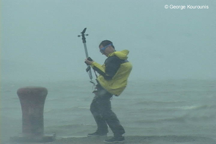
 http://www.stormchaser.ca/Hurricanes/Dennis/Dennis_005.jpg
Wind, is the natural movement of air throughout earth's atmosphere, and I mean in all different directions. It is caused by differences in atmospheric pressure, which is largely due to the unequal heating of the earth's surface. The air in the higher pressure gradient moves toward the lower pressure gradient. Hence the stronger the pressure gradient the strong the winds will be.
 
Now that you know what wind really is and what causes it, I also think that its important that you learn how it is measured and in what units wind can be measured in. When measuring wind speed near the surface you use a Anemometer, which is pictured above. Winds can also be measured by Pi-bal launching test and by radar. I have actually done many Pi-Bal launching test, look below and you will see me holding a Pi-Bal and some of my old classmates tracking the balloon as it ascends.
Meteorologist measure wind in knots or nautical miles per hour, however, wind can be measured in statue miles per hour and meter or feet per second.


Photo/ Info From:
stormchaser.ca
science.howstuffworks.com
daviddarling.info


Monday, January 28, 2013

Myth: Moist Air is Heavier Then Dry Air

Myth: Moist air is heavier then dry air. We assume moist, humid air to be heavier because we, humans, feel more weighted down when the dew point temperatures are high. This is because if the sweat on our bodies can't evaporate, then our bodies can't cool and in term feel weighted down by the air around us.
Lenticular Clouds Above Washington

Answer: False. Dry air is HEAVIER then moist air.

The Science: Well this sound just outrages doesn't it! But hold on let me explain.  Moist air is lighter because moist air which contains water molecules displace the nitrogen and oxygen molecules that exist in dry air. Nitrogen and Oxygen molecules are heavier than a water molecule, so more water molecules and less nitrogen and oxygen molecules, in a defined space would actually make the moist air lighter then dry air.

So next time someones says ugh the air is so heavy today, because it is humid outside you can tell them that actually it is lighter than usual!

Happy Monday! Hope you enjoy the picture of Lenticular Clouds over Mt. Rainier in Washington State.

Picture by: astronet.ru
Info From: poultryventilation.com

Friday, January 25, 2013

Friday: The 6 Most Snowiest Cities in the US

Looking at a 30 year annual average snowfall from the National Climate Center of the National Weather Service, the Weather Channel compiled a list of the top 6 cities that receive the most snow on average. To add dramatic effect I put them in reverse order.

Number 6: Boonville, New York
Claiming to be the "Snow Capital of the East", Boonville, which is located smack dab in Lake Ontario's snow belt, receives an average of 197.3" of snow per year. Cool westerly winds and some help from Orographic lifting, as known as mountains, help make this particular area prone to get tons and tons of snow.

Number 5: Lead, South Dakota
Lead, which is pronounced Leed, is located in the Northern region of the Black Hills. Influenced by many Canadian low pressure systems it's no wonder that Lead receives an average of 201.4" of snow per year. Pictured below is one of Lead snow storms in 2011.

Number 4: Truckee, California
Located near the north shore of Lake Tahoe, Truckee receives an average of 202.6" of snow per year. Most of the snow that falls in Truckee comes from strong Pacific storms. Truckee most infamous storm came in 1880, when a storm dropped a whopping 16 feet, yes I said FEET of snow, in a four day period. This is thought to be a world record. Truckee is also known for is frigid temperatures. Below is a picture of Truckee Christmas of 2011.

Number 3: Hancock, Michigan
Coming in at number 3, Hancock, located on the Upper Peninsula of Michigan, receives an average of 211.7" of snow per year. Influenced by both Lake Effect snowfall and strong Canadian low pressure systems it's no wonder they get all of this snow. And I suppose if you are going to live in the cold snow harsh environment, might as well celebrate it. Below is a Keweenaw County 1978 snow marker. Hancock is also known for their snowfall guessing contest.

Number 2: Crested Butte, Colorado
Located about 4 hours South West of Denver, Crested Butte receives an average of 215.8" of snow per year.  Sitting at an elevation of 8860 snow is quite common from November through March and is also not unheard of to have snow occur as late as June.
Number 1: Valdez, Alaska
Coming in at number one is Valdez, Alaska! Valdez receives an average of 326.3" of snow per year.  326.3 inches of snow is about 27 feet of snow per year. In 2012, they had a snow storm that buried the town alive. For more information about this event check out my earlier post Throwback 2012.


Have a wonderful weekend everyone! Stay warm!


Photo/ Info From:
weather.com
the-lovgrens.com
nilaewhite.wordpress.com

Wednesday, January 23, 2013

Wacky Weather: Snow Rollers

In light of recent events in Vermont, I thought that I would bring to your attention, mother nature's way of making snowballs. The meteorological term is Snow Rollers, and this rare weather phenomenon is quite cool!
Snow rollers have a pretty specific recipe which is why they are so rare. It occurs when wet snow falls on hard ice covered snow or an icy surface, which means that it doesn't really stick. Then you have high winds, in Vermont's case they had wind gust of 50 miles per hour. The snow is then pushed along by this strong wind and literally rolls along until the wind isn't strong enough to push it anymore. And that is how you get Snow Rollers!

Pretty cool in my book! Hope you enjoy your Wednesday!


Photo From:
minnesota.publicradio.org
wunderground.com

Tuesday, January 22, 2013

Forecasting 101: Relative Humidity and Dew Point

Both of these terms give a reading on how much moisture is in the air, however one is a little more reliable then the other.

Before I go into details about Relative Humidity and Dew Point I want to give you some handy information. Warm air can hold more water vapor then cold air. I'll repeat this warm air holds more water vapor then cold air.

Alright now that we go that covered, Relative Humidity is a calculated measurement. Relative Humidity is the percentage of how much water vapor is in the air over how much water vapor the air can hold at the current temperature and pressure. Hence, the term "Relative" Humidity. I found an equation that writes it out so that you can see what I mean. But to be clear, the maximum moisture the air is capable of holding changes with how warm or cold it is. 


I personally, think that Relative Humidity is confusing because it can be 50% relative humidity at just about any temperature. However, 50% relative humidity at 100 degrees is going to feel very stick then compared to 50% relative humidity at say 50 degrees.

A less confusing way to look at humidity is the Dew Point temperature. I love love love the Dew Point temperature. You can ask any of my friends how much I love this measurement. Why you may ask, well Dew Point is an actual measurement of the amount of moisture in the air. The Dew Point temperature is amount the current air temperature would need to decrease in order to reach saturation. The Dew Point temperature can NEVER be greater then the actual air temperature. I found a great chart below that can help you understand Dew Point Temperature.


Any questions, please don't hesitate to ask, this can be a confusing topic.

Photo From:
dampp-chaser.com
livecurlylivefree.blogspot.com
backyard.weatherbug.com

Monday, January 21, 2013

Myth: Crickets can tell the Temperature

Myth: By Counting the amount of times a cricket chirps, this will then correlate to the current temperature outside.

Result: Yes! Crickets may not always have the exact temperature but they are usually within one or two degrees of the current air temperature.

The Science: The frequency of the cricket chirp can be correlated to the current temperature. The more frequent you hear the chirp outside the warmer it is. To get a rough estimate of the current temperature by the frequency of cricket chirps. First count how many chirps you hear in a 15 second time span. Then take that number and add 37 to it. This will give you the temperature outside. If you aren't a math wiz just count how many chirps you hear in 15 seconds and put that number into the Cricket Converter courtesy of NOAA and it will do the math for you! Who said bugs weren't smart?!

Photo From:
littleoldhouse.blogspot.com

Wednesday, January 16, 2013

Wacky Weather: Sonic Booms and 131 Records Broken

131 record daily temperatures were broken in the United States last week. There were 81 record high temperatures set and 50 low record temperatures. One example was down in Atlanta where the high temperature was 76 degrees on January 12th, this broke a 123 year old record!


Some Sonic Booms were reported in Utah starting around 9pm. At first the US Air Force denied that they were the cause of the noise. But then later on Wednesday they took responsibility, reporting that it was B-52 bombing runs in the desert. So it totally wasn't aliens!


Photo From:
7reasons.org
11alive.com

Info From:
wunderground.com
11alive.com

Monday, January 14, 2013

Myth: Don't Touch a Lightning Victim

Myth: When lightning strikes a person, you should not touch them cause you will be electrocuted too.

Result: This is so false! Please go and help them!!

Scientific Reason: The human body cannot store electricity. If someone near you is stuck by lightning, it is perfectly safe to touch them and give them first aid.

Photo From:
msnbc.msn.com

Info From:
noaa.gov

Friday, January 11, 2013

Friday: Record Low Tornado Deaths

For the past 200 days, the United States has not seen a deadly tornado. (Knock on Wood). The last tornadic related death was during Tropical Storm Debbie when an EF-0 went through Venus, FL on June 24th, 2012. With a low tornado count for 2012 it's no wonder that we only saw 68 tornado related deaths in the states with only 936 tornadoes confirmed.

This picture is of the EF-0 tornado that caused the death on June 24th.

Hope you all have a wonderful weekend.

Photo and Info From:
wunderground.com

Wednesday, January 9, 2013

Wacky Weather: Temperature Extremes

If you don't live somewhere on the eastern side of the United States, I will tell you that they are experiencing quite a warm up and warmer temperatures are expected heading in to this weekend. Some major east coast cities could see temperature in the lower 60's this weekend.

While 60's is a nice break from the frigged temperatures experienced over the holidays, China has had a 30 year record breaking cold snap. Some regions in China are even reaching negative 40 degrees Fahrenheit. Brrrr!!

Another temperature extreme takes us down under, where they are reaching temperatures of 105 degrees. Remember it is summer in Australia, but forecaster are predicting daytime high temperatures to reach 125 degrees Fahrenheit by next week. Look at the cute Koala trying to stay hydrated!
 
That's it for your Wacky Weather! Happy Wednesday!

Photo From:
accuweather.com
usatoday.com
americanblog.com
Info From:
ouramazingplanet.com

Tuesday, January 8, 2013

Forecasting 101: Lake Effect Snow

I am sure common sense has told you that the Great Lakes are part of why the states surrounding them get so much snow during the winter months. But today, we are going to learn about what exactly the lake's part is in this process.

During early winter before the lakes have frozen, cool air passes over the relatively warm lake waters. As it does the lakes warm the bottom of the cool air. Then because warm air is lighter then cool air it rises. When the warm air rises it it starts to cool it condensates the water within the warmer air. This condensation will cause clouds to form and then with enough moisture present will start to precipitate in the form of snow. As you can see below the average annual snowfall map for the Great Lakes Region is quite impressive.

Now you may be asking yourself why doesn't this happen in the summer? Well, this phenomenon only works when it is cold because cool air holds less moisture then a warm cloud, hence a cooler cloud will precipitate faster then a warm cloud. 

Also the Lake Effect snow stops after the lakes have ice on them.

Photo From:
Fox11online.com

Monday, January 7, 2013

Myth: Lightning Never Strikes the Same Place Twice

Back to Monday Myth busting!! Today's myth is about the dangers of lightning.

Myth: Lightning never strikes the same place twice.

Result: This myth is not true. In fact, the Empire State Building get struck about 100 times a year by lightning (noaa.gov).

Reason: First I'll tell you a small background on lightning. A Cumulonimbus cloud (Thunderstorm cloud) has different charges within the cloud. There are protons or a positive charge at the top of the cloud. And there is electrons or a negative charge at the bottom of the cloud. Then the ground is mostly positively charged. The opposite charges within the cloud and on the ground creates lightning. This lightning will actually pass through a channel that was made through the air multiple times. Which is why you see multiple flashes of light sometimes. Lightning also looks for the shortest distance to the opposite charge which is why tall buildings and trees are struck by lightning more often then something lower to the ground. 


Hope you have a wonderful week! Happy Monday!

Photo From:
theatlantic.com 
britannica.com

Friday, January 4, 2013

Friday: Jan 1st Snow Cover

To wrap up your first week of 2013, I thought I would let you all know that on January 1st, sixty-seven percent of the nation was snow covered. The highest it has been in ten years.
http://www.nohrsc.noaa.gov/snow_model/images/full/National/nsm_depth/201301/nsm_depth_2013010105_National.jpg
Photo From: Noaa.gov
Info From: accuweather.com

Wednesday, January 2, 2013

Wacky Weather: Christmas Tornado Outbreak

Kicking off 2013 with some wacky weather!! There was a tornado outbreak in the Southeast on Christmas Day. At least 24 tornadoes were confirmed. Below is the storm reports for the 25th.

There was two EF 3 confirmed in this outbreak on was in Pearl River County, Miss. and another in Houston County, Texas.

This storm system was also the cause for numerous flight delays and cancellations around Christmas as well as blizzard like conditions across much of the northern states.

Photo Form:
noaa.gov