
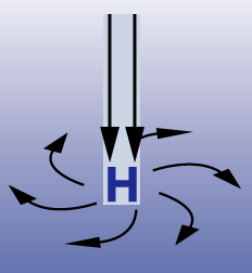
First, I am going to cover High pressure systems. High Pressure systems or as some meteorologist refer to them as Anticyclones, are regions of sinking air. Below I found a diagram of a high pressure system. As you can see there is sinking motion and the wind surrounding the high pressure are moving clockwise. High pressures are associated with nice and dry weather, however, some weak high pressures can have showers associated with them.
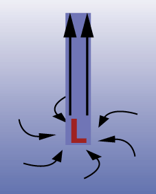
Now on to the low pressure systems. Low pressures have a few names for them, but to keep it simple for today they can also be know as cyclones. An area of low pressure have winds converging at the center causing an area of rising air. Like in the picture below. An area of low pressure winds flow in the opposite direction as a high pressure, counterclockwise. Because of the upward motion associated with a low pressure system, this causes clouds and usually some sort of precipitation. But don't always think that if you have a low pressure system that rain is coming.
Hope that helps differentiate what the heck the weatherman is saying on TV! I think next week I'll go into fronts to help bring it all together. Hope you are having a great day.
Photo From:
noaa.hpc.gov
windows2universe.gov
No comments:
Post a Comment