Cold Fronts
A Cold Front is when cooler air is advancing into an area with warm air. Cold fronts are denoted by a blue line with triangles on it. Cold fronts can cause thunderstorms and rain to form at or around the front. The photo below is a cross section view of what is happening at the surface when a cold front is moving into warmer air.

Below is a photo of what a typical cold front would look like if your weatherman was show it on television.

Warm Fronts
A Warm Front is when warm air is advancing towards an air who's current temperatures are cooler. A warm front is represented by a red line with half circles. Fun fact, all of the fronts will point in the direction that they are moving. Look at the picture above see how the blue triangles are pointed to the east, well that is the direction the front is moving. Anyway a warm front can also produce showers and storms at its boundary. I found a cross section of a warm front advancing into cooler air, take a look below.

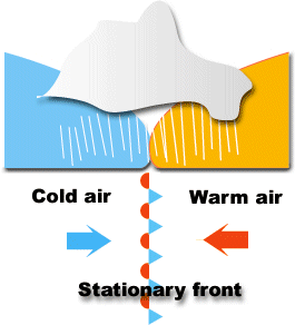
Stationary Fronts
The last type of front I am going to cover is called a Stationary Front. A stationary front occurs when the boundary of a cool and warm air mass isn't moving in on direction or another, therefore it is "stationary". I found a picture the perfectly describes what is occurring. Also a stationary front is denoted by an alternating warm front and cold front symbol, represented below. Precipitation is often found at this type of air mass boundary as well.
These are your main fronts that occur most often. Maybe I'll cover some of the special types of fronts later.
Photos From:
blogs.wdtn.com
yourweatherblog.com
rossway.net
sir-ray.com
No comments:
Post a Comment